TOURIST ATTRACTIONS

CHECK AVAILABILITY

TOURIST ATTRACTIONS

image

SHALBAN BIHAR & MAINAMATI MUSEUM

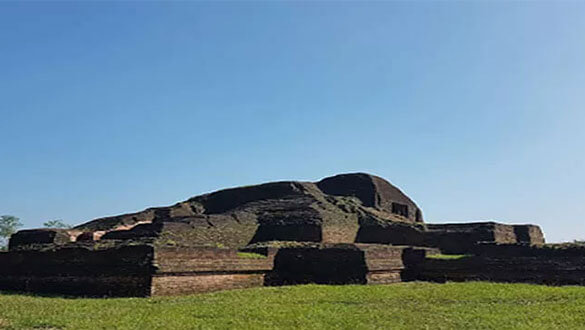
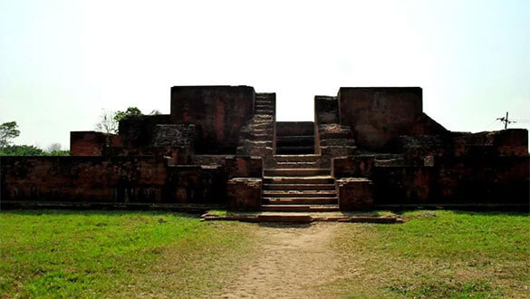
Shalban Buddhist Monastery is one of the ancient civilizations of Bangladesh. This Buddhist monastery is one of the many ancient sites of the Lalmai-Mainamati archeological site in Cumilla district. It is identified as the 12th Archaeological Site.

It is square in shape. Each arm of Shalban Bihar is 18.6 meters long. The walls on all four sides of Bihar are five meters thick. The rooms are built on the back walls of Bihar. There was only one way to get in or out of Bihar. This path or door is in the middle of the north block. Each room has a wall 1.5 m wide. The central temple was right in the middle of the Bihar courtyard.

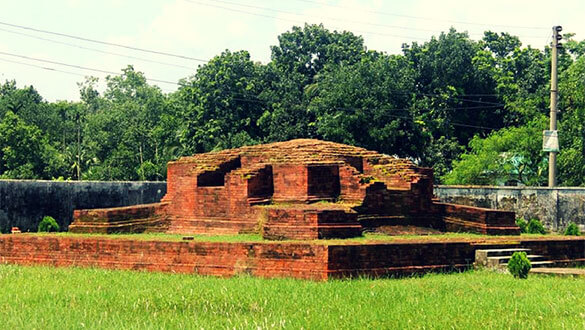
Archaeological excavations have unearthed eight copperplate inscriptions, about 400 gold and silver coins, numerous burnt earthen plates or terracotta, seals, bronze and clay statues. These bear the signature of the ancient archeological heritage of Bangladesh.

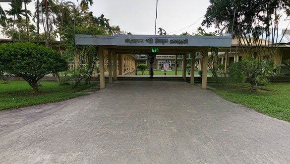
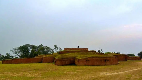
Many valuable antiquities were found during the excavations at Mahavihara, Kotila Mura, Charpatra Mura, Rupbanmura, Itakhola Mura, Ananda Bihar, Rani's Bangla, and Bhoj Raja's Bari Bihar. To preserve and display these antiquities, a west-facing museum was set up in 1985 in front of Shalban Bihar on the south side of Shalban Bihar in Cumilla Kotbari.

image

MAINAMATI WAR CEMETERY

Bangladesh has two cemeteries of World War II. One is in Chittagong, and another one is in Cumilla. Both of these are monitored and governed by the Commonwealth Grave Commission. If you are planning to visit the cemetery at Cumilla, then this blog has a little information that may help you. This cemetery is known as Cumilla war cemetery, Mainamati (or Maynamati) war cemetery, etc.

You can reach Cumilla by bus or train. It’s around a 2 hours bus or train journey (but requires more than that for the massive traffic jam). Asia Line and Tisha are the two affordable transport facilities that you can use. It will cost you 110 Taka. The final destination of the bus is Cumilla town, but it will be best for you to get down at Cumilla Cantonment. Because it’s a walking distance from the cantonment.

Maynamati Cemetery is open from morning 7:00am to 12:00pm, and from afternoon 2:00pm to 5:00pm. Without this timing you cannot enter inside the Cemetery, they are strict about the timing. So be careful about this.

image

Chondi Mura Temple

Chondi mura temple is located at the top of a hillock and you have to climb there using the stairs. It’s tiresome to reach the top. But don’t worry, you’d have the whole stairs covered with evergreen trees. And at any stage you could have a break by supporting your body on the railing of the stairs. You can see a long distance from there as you have already climbed a few.

Most of the tourist spots (from Cumilla) are somewhere around the other side of Shalbon Bihar of Cumilla. But this Chondi mura temple is quite isolated from those places. This is at the southern end of the Lalmai Hill. That’s why mostly the devoted people go there only. Very few tourists like us go there.

To visit Chondi mura temple you have to come to Lalmai Bazar first. From the bazaar, it’s 10 Taka auto rickshaw fare for each person.

The GPS coordinate of the temple is (23°21’9.62″N, 91° 7’52.42″E). There is a bus (named Bolaka) that runs through a road which is exactly beside the temple. You could take that bus from the Poduar Bazar of Cumilla Bishwa road. It’s 15 Taka per person and around 15 minutes of bus ride.

image

Jagannath temple

Jagannath temple is probably the oldest Temple from Cumilla district. It was built by the King of Tripura named Moharaja Rada Kishor Manikuo Bahadur during the 16th century. This temple worships the gods Jagannath, Balabhadra and Subhadra. Statues of those gods were initially placed at the temple of Tripura, but later those were shifted here. This temple is also known as Jagannath Mandir.

Wikipedia mentioned this as Saptratna Mondir whereas the travel book writer Mustafiz Mamun has introduced this as Sotero Rotno Mondir. It is not sure which one is correct but the temple seems unique to many people considering the other temples from Bangladesh.

This Jagannath temple is located mainly at the Bibir Bazar of Jogonnathpur which is 5 kilometers east from the Cumilla town.

First come to the Chawk Bazar of Cumilla town. From there you can take a Battery driven auto vehicle which costs 10 Taka per person. It will be around 15 minutes of journey. The GPS coordinate of the Jagannath Temple is (23°27’43.97″N, 91°12’39.24″E).

image

Bangladesh Academy for Rural Development

Bangladesh Academy for Rural Development works with the poor people all around. You can learn more about BARD from wikipedia. Also if you have more time, it is better to read it from BARD’s own website which is governed by the Bangladesh government.

Inside the BARD you’d find several places to spend your time. For example at the cafeteria, at the tennis ground, or other playgrounds. Also there are two places available inside BARD, one is Nilachal and another is Banasree. You can spend the whole day there, and enjoy your time. If you are in a group of 3/4 people then it’s one kind of fun. And if you are with a large group then that’s another fun.

You can reach Cumilla by bus or train. It’s approximately a 2 hours bus or train journey. I went there by bus. From my experience, Asia Lines and Tisha are the two affordable transport facilities that you can use. It will cost you 110 Taka per person

image

Rupban Mura

Rupban Mura is another archeological site from Cumilla. This is just beside the BARD at Kotbari, Cumilla. Most of the people visit the BARD but they miss the opportunity to observe the beauty of Rupban Mura for lack of knowing. So if you have gone to BARD, and never visited the Rupban mura, then you are unlucky for sure!

If you plan to visit the Rupban Mura, then you have to first reach Cumilla. This archeological site is just 200 meter apart from the BARD, Kotbari. So please read the How to go section from my other article BARD of Cumilla. The GPS coordinate of Rupban Mura is (23°26’10.84″N, 91° 7’45.90″E).

image

Itakhola Mura

Locally the site is known as Itakhola Mura. As a result of excavation a ground plan of an east facing Buddhist temple has been exposed. Five building and rebuilding phases have been found in the temple. Besides this the remains of a Vihara has been exposed on the northern side of the temple. Among the discovered antiquities are 18 tola solid gold, one silver coin, and a copper plate is noteworthy. Besides these a bust of a large size stucco image which is still insitu. In consideration of the antiquities and architectural features the temple may be dated in 7th to 12th century A.D. [This portion of the article was copied from others].

Most of the people use to visit Cumilla for the Shalban bihara, and never looked at a beautiful archeological site known as Itakhola Mura. This is located just around 200 meters apart from the BARD.

It was noon when we reached there, and the sun was hot and scorching. But there was a gentle breeze that was doing all the cooling for us. This place is near the BARD. If you read this article regarding BARD then you’d find the required information that you are looking for. The GPS coordinate of Itakhola Mura is (23°26’18.96″N, 91° 7’46.19″E).

image

Palace of king Bhoj

Palace of king Bhoj (or Bhoj rajar bihar) is near to the Itakhola Mura . This archaeological site is known as Palace of king Bhoj that falls inside the boundary of Army cantonment. The site is known as Bhoj Rajar Bihar or Bhoj bihar. It could be a praying place or a house of the King Bhoj. The whole premise is square shaped and has a central shrine in the middle.

Palace of king Bhoj is near the BARD. If you read this article regarding BARD then you’d find the required information that you are looking for. You have to enter inside the cantonment area through the check post. After that it’d be on the left side of yours. The GPS coordinate is (23°26’31.39″N, 91° 7’53.94″E).

image

Palace of Moynamoti Rani

This place is locally known as Moynamoti Ranir Kuthi, Moynamoti Ranir Banglo, etc. Textbook name is Moynamoti Ranir Bihar. This is a very less popular tourist spot from Cumilla. Hardly seen any tourists were wandering around here.

Palace of Moynamoti Rani is very easy to access. It’s just a kilometer apart from the Moynamoti war cemetery. If you are not familiar with the cemetery then consider the Cumilla cantonment. This place is 10 Taka or less auto rickshaw fare distance from the cantonment gate. If you come from Dhaka then leave the bus at the cantonment gate. GPS coordinate of the place is (23°29’46.06″N, 91° 6’27.53″E).